The proposed Cocanarup - Kundip Class A Reserve is a substantial and remarkably diverse area of complex and valuable landforms, plant communities, habitats and cultural sites and stories. Stretching some 20 km from north to south and almost 35 km east to west, it encompasses approximately 65,000 hectares of largely undisturbed bushland. It lies along the western flanks of Ravensthorpe Range, holds part of the Phillips River valley and envelops the low hills that run into Kundip at its eastern edge.
The exceptional natural diversity of the proposed reserve area is the consequence of a set of historic continental influences in its climatic history, complexity of underlying geology, great age and relative isolation, together with a Gondwanan plant heritage. It is therefore not at all surprising that the area supports such an array of unusual and in many cases rare or endangered species of flora and fauna. Nor is it surprising that this country was of such significance to Noongar people for millennia before European settlement. It is this astonishing multiplicity of values that has underpinned the long-time recommendations that the area be set aside as Nature Reserve. For details, see the "History of tenure recommendations" section below.
The net result is a unique place with combination of landscape, flora and fauna not yet represented in Western Australia’s conservation estate.
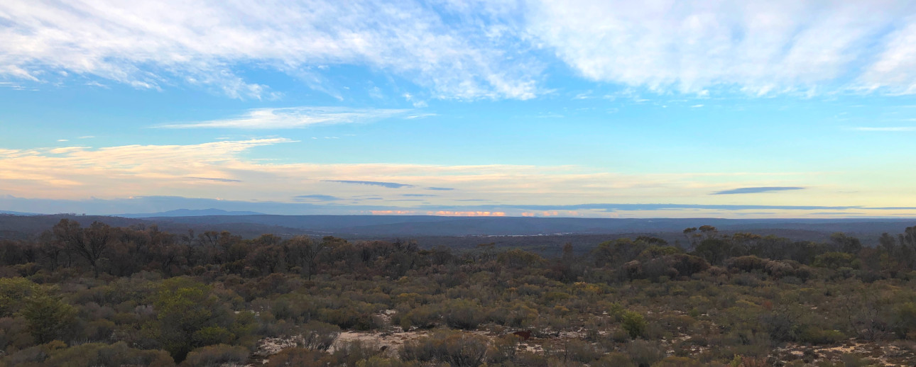 The view south over Cocanarup and all the way to the Eyre Range, from the Kukenarup Memorial
Courtesy Jesse Brampton
Big Picture Gallery
Geology
Geology
The proposed reserve features a complex underlying geology, riven with fault-lines along the boundaries of adjoining types and impacted by aeons of largely undisturbed weathering. In north-western parts the geology consists of the granites of the Yilgarn Craton, the southern edge of which lies across this part of the proposed reserve. The Yilgarn granite rocks are clearly evident at and downslope from the Kukenarup Memorial as bare sheets that dip south indicating the edge.
The low hills that are intersected by the Phillips River in the northern part of the area are underlain by rocks of the western Ravensthorpe Range as an ancient volcanic greenstone intrusion into the Yilgarn Craton. The banded iron and quartz formations of this intrusion can be seen exposed along the sides of the river south of Cocanarup Road, and a walk along the river bed in this area provides a view of the diversity of rock types liberated and exposed by the river flow.
In the southern part of the area, the Barrens Quartzite geology lays over the Yilgarn Craton and intrudes among volcanic greenstone formations. This is most visible on the surface west of Kundip. The quartzite is metamorphosed sedimentary rock that started as an ancient sea floor that was later exposed and weathered to form sandstone. Then much later this was overlain by the actions of continental rifting that heated and pressured the sandstone into hard quartzite that was eventually exposed by millions of years of erosive forces as surface rock.
In a few places sections of the sedimentary Spongolite rock formed on the Eocene sea floor are apparent. These soft rocks formed when the sea-sponges that were then the dominant sea-floor life mixed with sediments and the result was exposed to the air as the ocean receded.
The broad evolutionary story of the landforms of the area is that the hardest rocks provide a resistant or obdurate mantle that retains height and form as hills and so-called mountains after all the surrounding softer material has weathered away.
This complex geology has long attracted interest from prospectors and mining companies; however as can be seen on the map below, it appears that all but one of the historic mines have been outside the proposed reserve area, mainly in the Ravensthorpe Range and to the north of town.
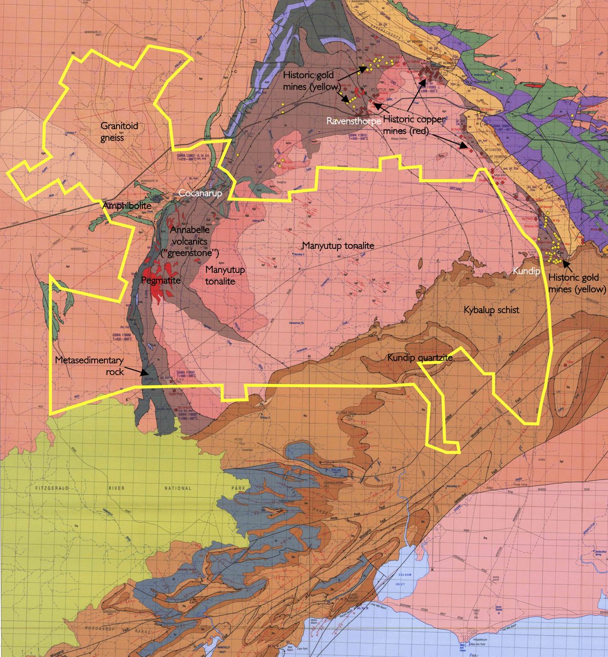 This map shows that all of the numerous historic mines in the Ravensthorpe region have been outside the proposed reserve area
Image by Jesse Brampton. Base map courtesy WITT, W. K.,1998, ‘Geology and mineral resources of the Ravensthorpe and Cocanarup 1:100 000 sheets: Western Australia Geological Survey, Report 54’
Linkages and corridors
Linkages and corridors
Major projects such as Gondwana Link recognise and amplify the importance of connections in the natural landscape. The creation and/or preservation of corridors which enable the “flow” of biodiversity from one region to another is considered crucial to maintaining the healthy ecosystems on which humanity still depends.
The proposed Cocanarup - Kundip Class A Reserve forms a vital component of a hugely significant linkage – being from the reserves of the south coast (and primarily the Fitzgerald River National Park) to the vast intact inland region known as the Great Western Woodlands. This connection is immediately apparent on satellite photography – and is clear to see on CCA’s mapping of the proposed Reserve.
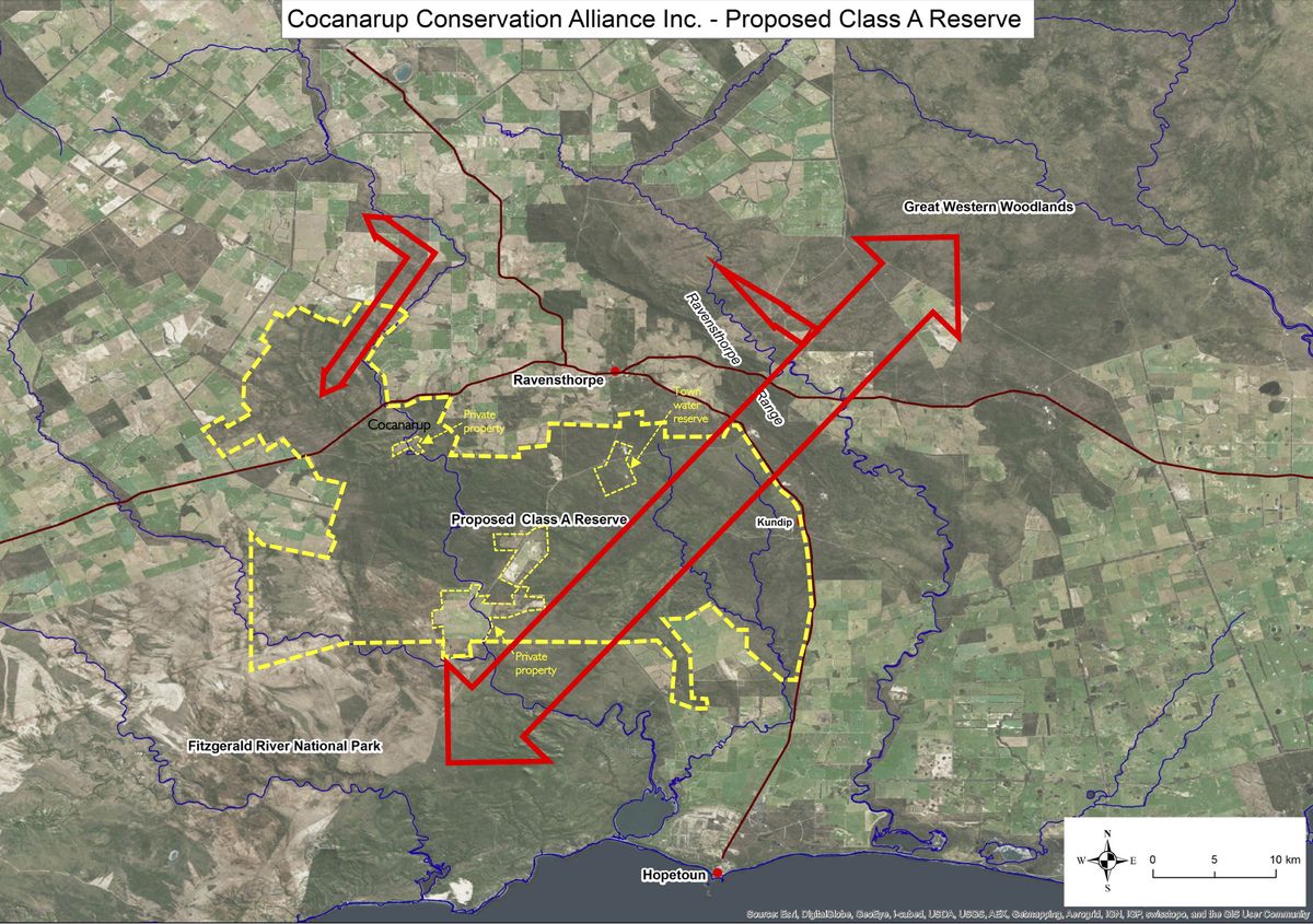 The Cocanarup – Kundip area preserves vital landscape corridors
Image by Jesse Brampton
This critical connection is already somewhat fragmented by farmland, mining, the town of Ravensthorpe and the South Coast Highway. Further exploration and mining activity has the capacity to exacerbate this fragmentation, undermining the wider work of the Gondwana Link project and negatively impacting a host of species and landscape-wide functions that are vital to the overall health of the area.
Our proposal also protects a significant secondary corridor, up the Phillips River valley to the north. Cocanarup adjoins a further 20 km of existing reserves upriver and is therefore vital to the integrity of this extensive riparian ecosystem. Given these two linkages, it is our belief that the area warrants secure conservation on the basis of its connectivity alone.
History of tenure recommendations
History of tenure recommendations
CCA Inc. is not the first organisation to recognise the importance of the natural values of the proposed reserve area. Reports and documents prepared by the Department of Biodiversity, Conservation and Attractions and its various predecessors have recommended the area – or at least core parts of it – be set aside as a part of the conservation estate since at least 1974. A comprehensive list of these vesting and tenure recommendations can be found here.
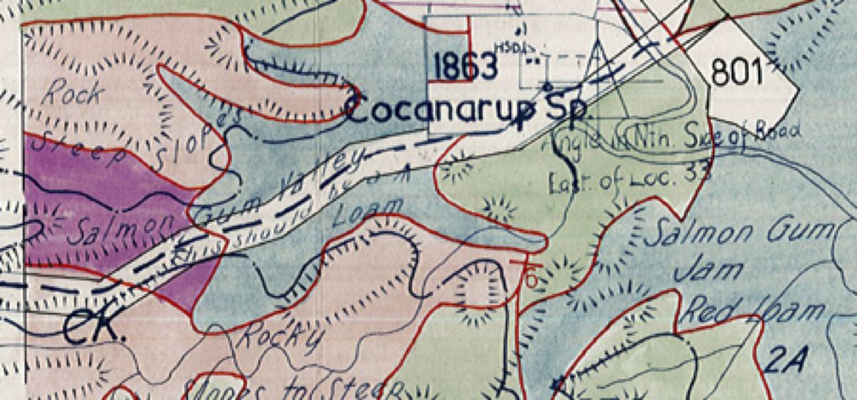 This excerpt from a beautiful hand-drawn map from the 1970s shows the area west of Cocanarup as “Salmon Gum Valley - this should be a (symbol) reserve”
Source: Forests Department historic files
A key step in this process came in 1992 when the South Coast Regional Management Plan prepared by the then Department of Conservation and Land Management recommended that the great majority of the proposed reserve area be set aside as a Nature Reserve. This recommendation is still reflected on DBCA’s field mapping, with “Proposed Nature Reserve” appearing in many places across the Cocanarup – Kundip Class A Reserve area. Senior Departmental staff have also confirmed that this remains the official position with regard the desired vesting of this landscape.
Phillips River
Phillips River
The Phillips River is a major regional landscape feature, with the broad and prominently incised valley slicing across the Ravensthorpe Shire in a largely north-south direction. The scale and importance of the valley would be clear to travellers driving the South Coast Highway, with significant descents on either approach. The view along the watercourse from the vicinity of the highway bridge is impressive in itself.
The river is around 120 km long, with a catchment of more than 2300 square kilometres, of which some 35% of the upper catchment is in cleared farmland with the remainder in either the proposed Class A Reserve area or the Fitzgerald River National Park. It rises on the Yilgarn plateau north of Mt Madden, flows southward parallel to the Ravensthorpe Range before being turned east by the Barren Ranges to exit into Culham Inlet, just west of Hopetoun.
Rivers such as this are recognised for their ecological service function, their amenity and scenic value, their conservation value (particularly for waterfowl, fishes and invertebrates) and for their recreational and commercial fishing opportunities. As noted elsewhere, the riparian vegetation of the valley also provides an important corridor between coastal and inland environments.
It is clear that the Phillips River valley was a landscape of importance to Noongar people long before the arrival of Europeans. A cursory study of topographic maps has produced a list of 12 place names in the valley that clearly have Aboriginal origins – this list can be found under 'Noongar connection to this country' here. Despite this, the river bears the name of a European settler who did not even live in this region, Samuel Pole Phillips, a wealthy landowner from Toodyay and the son-in-law of explorer John Septimus Roe.
CCA would be highly supportive of the co-naming of the River – or at least parts of it – should Noongar elders desire this in the future.
